The last two winters I have been able to escape from the drudgery of Toronto and this one would be no different. I had a few options on my plate: cycling across Cuba, hiking in Patagonia or revisiting Aotearoa(New Zealand) but this time to hike it's length. Feeling strong after completing the CDT and not wanting to worry about logistics needed to travel to a non-Commonwealth country, Aotearoa was the easy choice.
I've been to the country before and I assumed the trail, the Te Araroa(TA), was well cut and graded as the only thing people mentioned about it was that there was quite a bit of road walking in the northern half. Having done the Florida Trail with it's copious amount of road walking this seemed fined to me. I had visions of myself as a modern day Frodo Baggins about to begin their journey across Middle-Earth. I only gave serious thought to hiking southbound(SOBO) and would start late November with a loose deadline to finish by April.
Flying from my home in Toronto, I had a connecting flight in Vancouver then straight to Auckland. From the airport it was about 10NZD to take transit to the downtown area where the following day I caught a bus to Kaitaia. That's as far as public transit will get you and so the rest of the way to the top at Te Rerenga Wairua(Cape Reinga) would be strung together with hitchhiking.
Better to get comfortable by hitchiking +100km now since it'll be a versatile tool in Aotearoa with locals being extremely friendly and willing to pick up hikers!

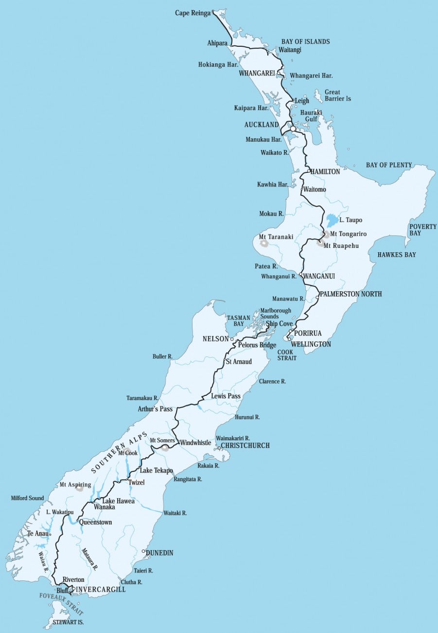
3000km(1864mi) from tip to tip across the two main islands of Aotearoa. Roughly three to four months of hiking depending on your pace. The best weather window lasts from November to the start of April, affording the least amount of rain and warmest temperatures. The track is almost always well-marked but almost always not well cut. It is rugged and the climbs are steep so be prepared.
The trail association has a great website here that answers a lot of questions you may have as well as providing maps and notes for the whole track. There is an officially linked navigational app on that website but I have opted to use the FarOut which I'm more accustomed to from my previous thruhikes for navigation. I'd say a majority of hikers use both apps.
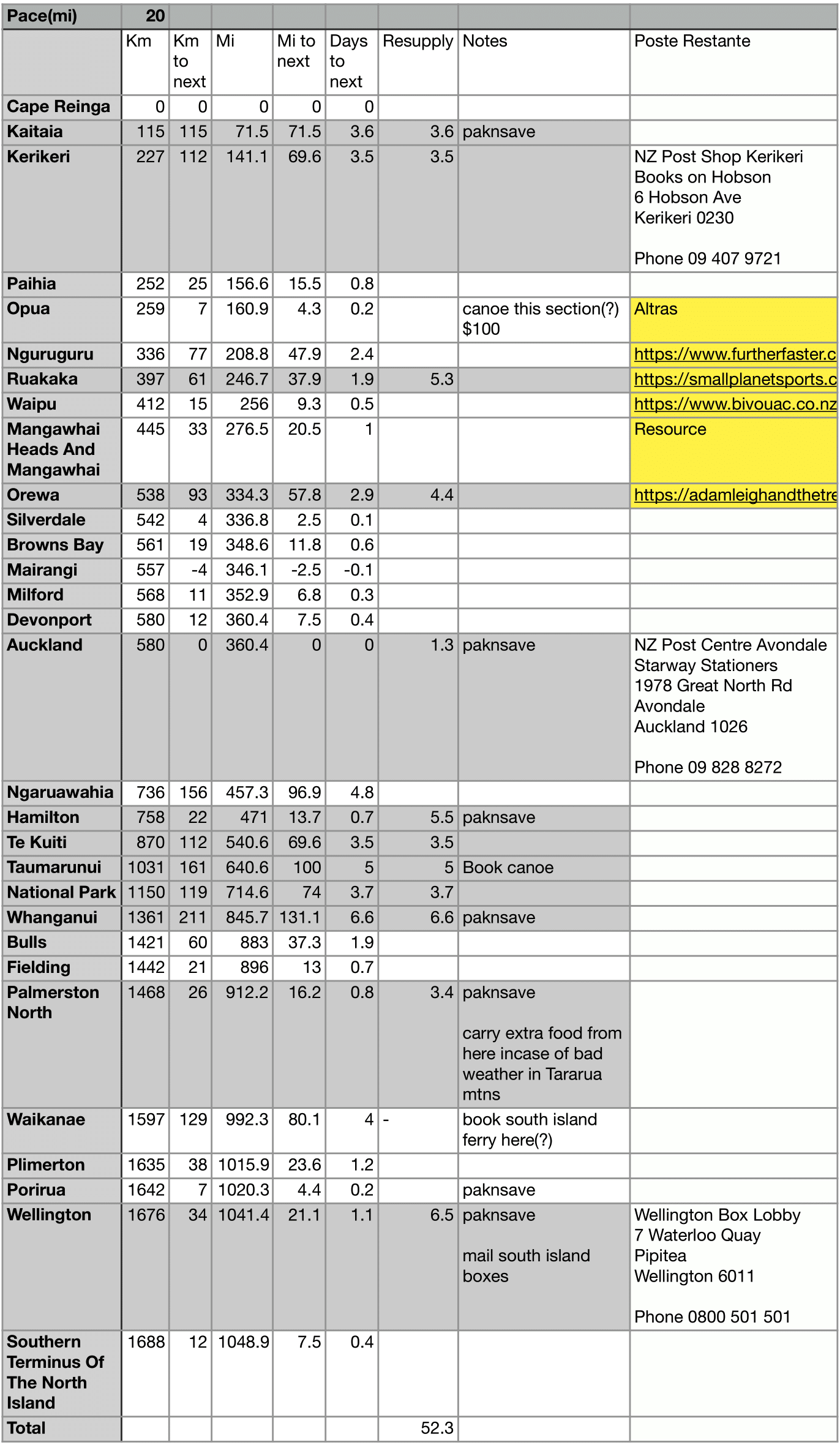
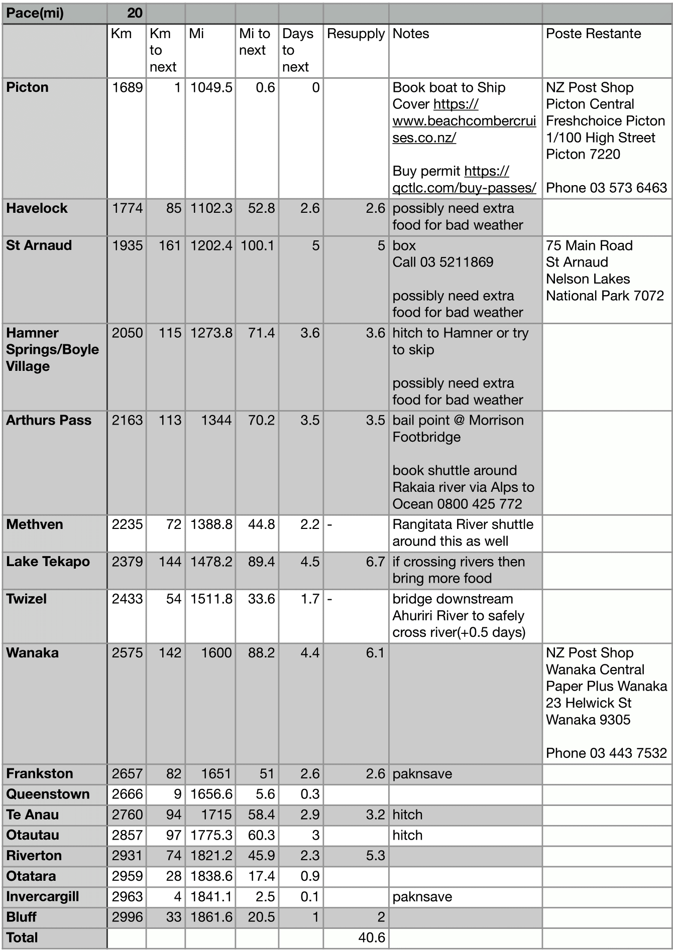
Resupplying is fairly easy along the whole hike. There is only one spot where I was forced to spend a lot of money(St Arnuad) but otherwise I was able to hike the whole length of Aotearoa just by showing up in town and buying food. (NO boxes are necessary despite what others may say)
Here is my North Island resupply strategy:

Here is my South Island resupply strategy:

Yet another ultralight hiking trip for me, surprise, surprise. I'm taking a 30F(-2C) sleeping bag and leaving my warm layers behind. The only thing I'm adding from my usual setup is a small towel and a sewing kit.
Table of all items and weights
Detour as much as possible!
The Te Araroa is a great first start for exploring the country but it oftens avoids stunningly beautiful areas for some reason. Take full advantage of the
Department of Conservation(DOC) website
that details every hut and most hiking trails across the country.
Take a look at my guide detailing the major alternates that are easy to incorporate into your TA thruhike. Even just adding one or two of these will create memories that you won't regret.
Be prepared to be wet and muddy
Torrential rain fall and mud up to your knees. Not much more to be said here, just know it's coming and there will always be more waiting ahead of you.
He used often to say there was only one Road; that it was like a great river: its springs were at every doorstep, and every path was its tributary. "It's a dangerous business, Frodo, going out of your door," he used to say. "You step into the Road, and if you don't keep your feet, there is no knowing where you might be swept off to."
Day by day journal of the trip:
Next Story