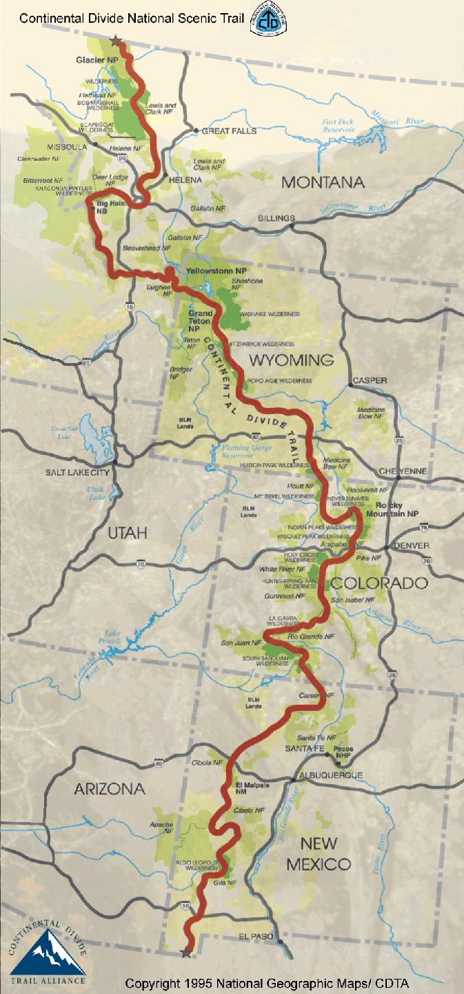
I've been looking forward to hike the Continental Divide Trail(CDT) since early 2022 when I met Ricky Bobby and Sea Biscuit on the AZT. They had hiked the CDT together and would often talk about it. After recovering from a foot injury while riding the Baja Divide in January earlier this year the time has finally come!
2023 was a crazy snow year in the southern United States. Both the PCT and CDT would be difficult to traverse northbound(NOBO). My friends had encouraged me to do a southbound(SOBO) hike but I was antsy and decide to start NOBO late hoping the snow would be manageable when I arrived in Colorado.
For my NOBO start I flew from Toronto to Tucson, then took an Amtrak train to Lordsburg in New Mexico. From there I'd paid for an official shuttle by the CDTC to the Crazy Cook monument at the Mexican border.
Link to book a shuttle to southern terminus.
For my SOBO start I flew from Toronto to Kalispell, then got lucky and found somewhere to crash in Columbia Falls. From there I got a ride into Glacier National Park and then hitched the rest of the way to start at Chief Mountain. Otherwise I was planning on walking to Whitefish, taking an Amtrak to East Glacier and then hitch to Chief from there.

For this nearly 3000mi(4830km) journey across the US I'll be using my phone for navigation via the FarOut app. The CDT is notorious for not being well marked so the GPS functionality will be extremely useful and the water reports from other hikers can be life saving.
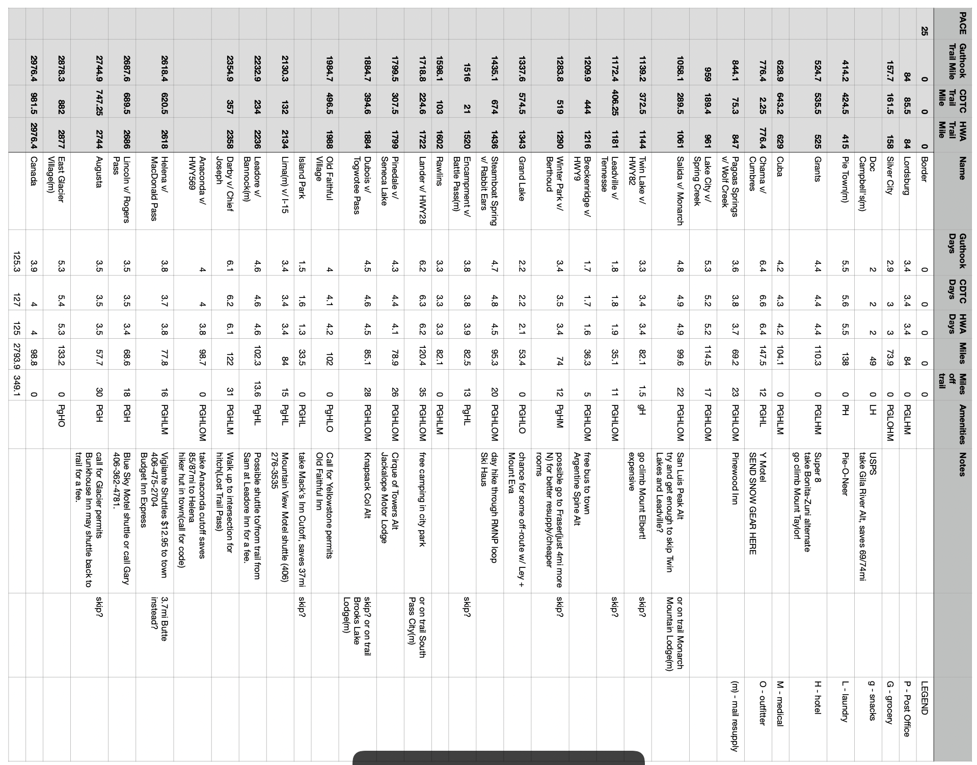
My resupply strategy is mostly based on the fantastic information gather by Halfway Anywhere and his CDT survey he ran for 2022. By looking at the suggestion of hundreds of hikers and what they had done I was able to form my own plans.

The plan is to continue to use an ultralight gear system but I had some major upgrades to my old set up. Namely I bought a larger pack, moving from 36L to 43L so I could fit a 20F(-6C) sleeping bag and a larger sturdier tent to handle the chaotic weather along the trail.
New Mexico will require more water carry through the desert so I will have capacity for 3.5L. Colorado will be colder so extra layers, a good sleep system and possibly snow gear are needed. Wyoming will be buggy and also very dry in the basin. Finally Montana has grizzly bears so bear spray needs to be considered!
Table of all items and weights
Read and use the CDT surveys
One of the single greatest resources out there and it's free. It covers almost every logistical aspect of hiking the CDT that you may feel tentative about. I used it almost religiously for my resupply planning but it also gives you data on everything from gear to time you can expect to be alone.
Explore the trail with Ley maps
Another insanely amazing resource that is free.
Jonathan Ley
is a legend who released maps way back in the day that have a ton of great alternate routes or side treks that get you climbing peaks, dipping into valleys and scrambling along beautiful ridges. No CDT hike is complete without at least trying one Ley cross country route.
You can get the maps from here. I recommend using the Avenza app to view and navigate with the maps (details can be found in the link as well).
Here is an article summarizing all the alternates that I did on the CDT.
Detour to
Grand Teton National Park
You'll be at your strongest by the time you are in Wyoming so why not explore the length of another entire national park! It's is quite easy to do. No extra permits and it only adds about 60mi(97km) to your total trip. The views are well worth it!
Here is my guide on how to incorporate the Tetons into your CDT hike.
And so off I go to try and complete my first hike of the Triple Crown!
Day by day journal of the trip:
Next Story